Publications
|
Development and Application of a Geo-temporal Atlas for Climate Change Adaptation in Bay of Fundy DykelandsAuthors: Danika van Proosdij, Barbara Perrott and Ken Carroll
Publication: Journal of Coastal Research Abstract: Globally, dykelands are of strategic importance for climate change adaptation. In the Bay of Fundy, these were originally designed to protect agricultural land, yet now protect valuable infrastructure. The purpose of this project was to develop a comprehensive digital atlas incorporating historical marsh plans, shore protection, coastal geomorphology, LiDAR and topographic dyke surveys to serve as a basis for climate change adaptation. 110 paper plans were scanned, geo-referenced and features such as current and historical dykes, aboiteaux, armouring, ditches, creeks, property boundaries, foreshore marsh, and geodetic elevations were digitized using ArcGIS. Attributes included age of structure, material, dimensions, and ownership. Dyke elevations were surveyed using an RTK GPS, and individual sections were identified as being vulnerable to storm surge and sea level rise. Erosion rates and width of foreshore marsh were calculated per dyke segment. At present, 55% of dykes within Nova Scotia are within 0.5 m of critical elevations established in the 1960s, 2% are more than 0.5 m below critical and all are below the predicted rates of SLR by 2055. There is also a strong relationship between the placement of armouring along the dyke toe and foreshore erosion. Conversely, timely placement of armouring along the foreshore marsh decreased rates of erosion. This was most effective in areas with the largest fetch; less effective where erosion was driven by tidal currents. All data were integrated into ArcReader for use by Agriculture personnel and have been essential for cost effective climate change adaptation including dyke topping, education and planning. |
|
Nova Scotia Department of Agriculture - Marshlands AtlasAuthors: Barbara Pietersma-Perrott and Danika van Proosdij
Publication: Atlantic Climate Adaptation Solutions Association (ACASA) Abstract: As part of the Nova Scotia Department of Agriculture’s (NSDA) commitment to the Climate Change Action Plan, the NSDA undertook a project to create an updated inventory of the dykes and flood control structures it maintains around the Bay of Fundy, specifically around the Cumberland Basin and the Southern Bight of the Minas Basin. As part of NSDA’s commitment SMU was contracted to create a GIS product to depict historic and current day dyke and flood control structures. The resulting product is a forty-two map atlas of the marshland and dyke structures of Hants, Kings and Cumberland County. The atlas has become a valuable resource for the NSDA as the data is digital and can therefore be searched and queried. For example a map user can easily determine the length of a dyke, its height, the aboiteaux along the dyke and protection in front of the dyke. The current survey data can be used to determine areas along a dyke which are vulnerable to overtopping and in turn management decisions regarding dyke construction and maintenance can be made. |
|
Shore Zone Characterization for Climate Change Adaptation in the Bay of FundyAuthors: Barbara Pietersma-Perrott and Danika van Proosdij
Publication: Atlantic Climate Adaptation Solutions Association (ACASA) Abstract: The purpose of this project was to develop an integrative GIS geodatabase of coastal zone characteristics including geomorphology, elevation, slope, vegetation, exposure, erodibility and built features as well as assessing areas of shoreline at continued risk of erosion with the Fundy ACAS study sites. This project serves as the foundation to address one of the goals of the ACAS program by “assessing the risks and vulnerabilities of select coastal communities in order to inform adaptation decision making at the local level” (www.atlanticadaptation.ca) which are discussed in greater detail in a series of companion reports. These include: van Proosdij & Pietersma-Perrott Best Management Practices for Climate Change Adaptation in Dykelands, Pietersma-Perrott & van Proosdij Marshland Atlas, and two MSc in Applied Science projects with associated reports: Tibbetts & van Proosdij A Relative Vulnerability Assessment Tool for Macrotidal Environments and Fedak & van Proosdij Hydrodynamic Flood Modelling within Fundy Dykelands: Windsor Case Study. Excerpts from these projects are provided within this report to illustrate the utility of the shore zone characterization for vulnerability assessment and climate change adaptation planning. |
|
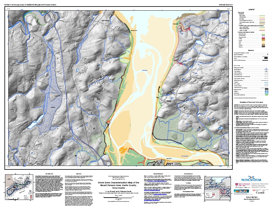
Shore Zone Characterization Map of the Mount Denson Area, Hants County, Nova ScotiaAuthors: Barbara Pietersma-Perrott and Danika van Proosdij
Publication: Atlantic Climate Adaptation Solutions Association (ACASA) Abstract: This project is part of the Atlantic Regional Adaptation Collaborative (RAC) Program of the Atlantic Climate Adaptation Solutions Association (ACASA). It was completed within the Maritime Provinces Spatial Analysis Research Centre (MP_SpARC) with collaboration from the Nova Scotia Department of Natural Resources (NSDNR). There are 15 maps in the Southern Bight of the Minas Basin study area and 7 maps in the Cumberland Basin study area. Maps are at a scale of 1:10,000. |
